We are Gilgit,Pakistan based Tours and Treks company.We welcome all the adventurous people out there, who would like to explore Chitral,Gilgit, Baltistan.
Our services are:
Treking.Jeep Safari. Cultural, Community and home stay trips.Horse Back Trips.Fishing.Hunting.Eco Tourism.Bike Trips.Mountain Climbing and many more....
Welcome to Hindukush Karakoram Tours & Treks Blog. We are small but highly exclusive and adventurous company therefore we treat our guests with utmost exclusivity. We would like to give a brief info about our services:
Background:Ayub Khan and Murad Khan started as young guides with Hindukush Trails in 1993 and after years of traveling experience, they gathered information of secret and exotic places where one could only dream of going there. After years of commercial driven trips we finally realised that there was a need of a company that could make their clients feel at home like a family and community therefore after careful consideration we have formed Hindukush Karakoram Tours & Treks for all the people out there who really want to know about Pakistan Recently Mr Amin Shah from Thui Yasin and Ms Billie Khan from UK become part of HK Tours and Treks. Amin Shah got more then 25 year tourism experience under his belt.So now we have a complete group of tourism professional where you can not be disappoint to "EXPLORE HIDDEN TREASURES OF PAKISTAN" with us from SOUTH to the NORTH.We arrange home stay trips to involve the local mountain community where our client have the opportunity to observe the real village life closely.Also we introducing newly discovered unspoiled hikes and treks in the north of Pakistan.So book your trip today with HK Tours and Treks and get the experience of different Pakistan
WE OFFER
Trekking,
Hiking
Jeep Safari
Cultural Tours
Community Cultural Enrichment Trips
Home stays
Horseback Trips
Yak Trips
Trout Fishing
Trophy Hunting
Eco Tourism
Bike Trips
Bird Watching Tours
Sports and Music Trips
Honeymoon Trips
Fairytale Mysteries Tours and MORE
Contact
HEAD OFFICE
HINDUKUSH KARAKURAM TOURS &TREKS
IN AD TOURISM OFFICE GAHKUCH DISTRICT GHIZER GILGIT-BALTISTAN PAKISTAN
BRANCH OFFICE
YASIN HOUSE Al SABAH CHOWK SONIKOT JUTIAL GILGIT. GILGIT-BALTISTAN PAKISTAN
K2 or Mount Godwin-Austen, peak, 28,250 ft (8,611 m) high, in the Karakorum range, N Kashmir, on the China-Pakistan border; second highest peak in the world. It was discovered and measured by the Survey of India in 1856, and first named for English topographer Henry Godwin-Austen , who explored and surveyed the region. "K2" is taken from the first letter of Karakorum, and the number indicates that it was the second peak in the range to be measured. An Italian team led by Ardito Desio reached the summit in 1954
Trek to Concordia
Concordia is the name for the confluence of the Baltoro Glacier and the Godwin-Austen Glacier, in the heart of the Karakoram range of Pakistan. It is located in Baltistan region of Pakistan. The name was applied by European explorers, and comes from this location's similarity to a glacial confluence, also named Concordia, in the Bernese Oberland, part of the Central Alps.Around Concordia are clustered some of the highest peaks in the world. Four of the world's fourteen "eight-thousanders" are in this region, as well as a number of important lower peaks.Concordia offers the region's best place to camp for mountain enthusiasts not involved in climbing. With breathtaking views, it also offers short hikes to several important base camps: K2 (five hours), Broad Peak (three hours) and the Gasherbrums (five hours). An alternative exit to returning down the Baltoro Glacier is available by climbing the Gondogoro Pass (5450 meters).
Nanga Parpat(Killer Mountain) 8125m
Nanga Parbat was first climbed on July 3, 1953 by Austrian climber Hermann Buhl, a member of a German-Austrian team. The expedition was organized by the half-brother of Willy Merkl, Karl Herrligkoffer from Munich, while the expedition leader was Peter Aschenbrenner from Innsbruck, who had participated in the 1932 and 1934 attempts. By the time of this expedition, 31 people had already died on the mountain.[11] The final push for the summit was dramatic: Buhl continued alone, after his companions had turned back, and arrived at 7 p.m.; the climbing being harder and more time consuming than he had anticipated. His descent was slowed when he lost a crampon, and caught by darkness he was forced to bivouac standing upright on a narrow ledge, holding a small handhold with one hand. Exhausted, he dozed occasionally, but managed to maintain his balance. He was also very fortunate to have a calm night, so he was not subjected to wind chill. He finally reached his high camp at 7 p.m. the next day, 40 hour
Sun Rise at Nanga Parbat
The Himalayas are a great mountain range. The central Himalayan mountains are situated in Nepal, while the eastern mountains extend to the borders of Bhutan and Sikkim. The Nanga Parbat massif is the western corner pillar of the Himalayas. It is an isolated range of peaks just springing up from nothing, and is surrounded by the rivers Indus and Astore. Nanga Parbat or "Nanga Parvata" means the naked mountain. Its original and appropriate name, however,is Diamir the king of the mountains.
Rakaposhi 7788m
SHORT DESCRIPTION: Rakaposhi is a mountain in the Karakoram mountain range. It is situated in the Nagar Valley approximately 100 km north of the city of Gilgit. Rakaposhi means “shining wall” in the local language. Rakaposhi is also known as Rakaposhi Peak. Rakapushi and Dumani (“Mother of Mist”). It is ranked 27th highest in the world and 12th highest in Pakistan, but it is more popular for its beauty than its rank might suggest and is said to be one of the most beautiful mountains in the worldRakaposhi was first climbed in 1958 by Mike Banks and Tom Patey, members of a British-Pakistani expedition, via the Southwest Spur/Ridge route. Both of them suffered minor frostbite during the ascent. Another climber slipped and fell on the descent and died during the night..Rakaposhi was first climbed in 1958 by Mike Banks and Tom Patey, members of a British-Pakistani expedition, via the Southwest Spur/Ridge route. Both of them suffered minor frostbite during the ascent. Another climber slipped and fell on the descent and died during the night.
Kalash Valley Chitral
Kalash Valley: Where Fairies Dance and Sing.Obscured by high mountains and treacherous muddy tracks, there live a people up in the north of Pakistan, who do not even know who they are or from where they came to live a life of isolation - yet maintain and protect their beliefs, their ideology and way of living. Their ancestry is enveloped in mystery and has always remained a subject of controversy. A legend says that five soldiers of the legions of Alexander of Macedonia settled in Chitral and are the progenitors of the Kafir-Kalash. One can still find similarities between the sports and games (specially the wrestling and shot-put style with those practiced in the ancient Olympics. Their features are not local and are thought to resemble those of the South-European characteristics. Some even find their influence of Greek music in Kalash music. Alexander the Great when encountered Kalash, he is said to have remarked that he encountered strange wooden boxes, which his troops chopped up to be used as firewood. These "boxes" were actually coffins for their dead following the custom which the Kalash of Chitral still have of leaving their dead outside in wooden coffins. He also described them as a light skinned race of European type people, which is exactly what they are. Kalash ruled over the areas now part of the Chitral Valley and neighbouring Afghanistan for three centuries (1200-1400AD). Remnants and ruins of Kalash forts can still be seen Uchusht and Asheret . The famous bridge over Chitral River known as Chew Bridge was also built by a Kalash ruler. The names of Bala Sing, Razhawai and Nagar Shao are still alive in the folklore of Chitral. They were the most prominent among the eight Kalash Kings.
Naltar Lake.
Naltar Lake Gilgit-Baltistan
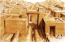
Indus Valley Civilization
This land also witnessed the glorious era of Indus civilization about 8000 years B.C when the first village was found at Mehargarh in the Sibi District of Balochistan comparable with the earliest villages of Jericho in Palestine and Jarmo in Iraq. Here, during the last decade i.e., 1980’s, the French and Pakistani archaeologists have excavated mud built houses of the Mehargarh people and their agricultural land known for the cultivation of maize and wheat, together with polished stone tools, beads and other ornaments, painted jars and bowls, drinking glasses, dishes and plates.The archaeologists believe that by 7000 B.C., the Mehargarh people learnt to use the metal for the first time. From the first revolution of agricultural life the man moved to another great revolution in his social, cultural and economic life. He established trade relations with the people of Turkmenistan, Uzbekistan, Iran and the Arab world. He not only specialized in painting different designs of pottery, made varieties of pots and used cotton and wool but also made terracotta figurines and imported precious stones from Afghanistan and Central Asia. This early bronze age Culture spread out in the countryside of Sindh, Balochistan, Punjab and North West Frontier Province of Pakistan.
Harappa
The Harappan civilization experienced its height around 2500 BC and began to decline about 2000 BC. The causes of its downfall , like that of Moenjodaro, are based on speculations and theories since Harappans disappeared without leaving any trace. One theory suggests that the Aryan people migrated into this area. Aryan religious texts and human remains in Mohenjo-Daro suggest that the Aryans may have violently entered the area, killing its inhabitants and burning the cities. Some believe that the periodic and frequently destructive flooding of the Indus finally took its toll on the economic health of the civilization. It is possible that the periodic changes of course that the Indus undergoes also contributed to its decline. It is widely believed that somewhere between 1800 and 1700 BC, the Harappan cities and towns were abandoned and finally reclaimed by the rich soil they had sprung from. A more recent evidence suggests that this civilization may have begun to decline before the Aryans arrived. The inhabitants of the Indus valley dispersed before the Aryans slowly entered the area as a nomadic people. The Aryans were then able to take over this area since most of the inhabitants had previously left. One cause of the dispersal of the Harappans could have been a result of agricultural problems. Topsoil erosion, depletion of nutrients from the soil, or a change in the course of the Indus River may have forced these people to leave their towns and move north-eastward in search of more fertile land


.gif)
